Interactics
Your Partner for Premier Interactive Solutions

Your Partner for Premier Interactive Solutions
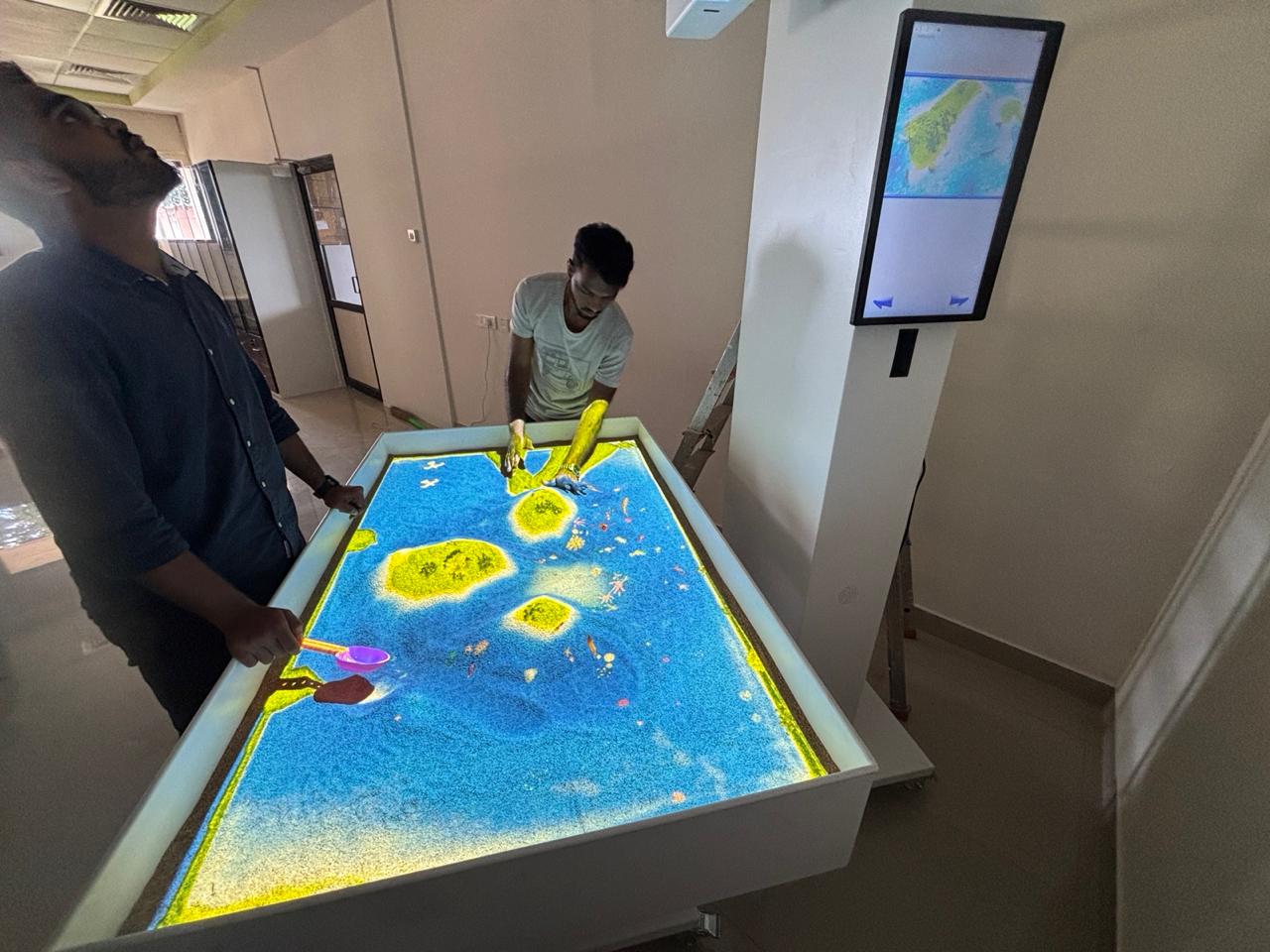
The Interactive MAP Sandbox is a cutting-edge, Projection based digital exhibit that lets users explore the world like never before.
Designed for Army,Aerospace,Navy,Education, Public engagement, and play, it transforms ordinary sandboxes into fully interactive geographic experiences.
🌍 View real-world maps with satellite, terrain, and hybrid modes
🔍 Pan and zoom using touchscreencontrols across the Topographic Map
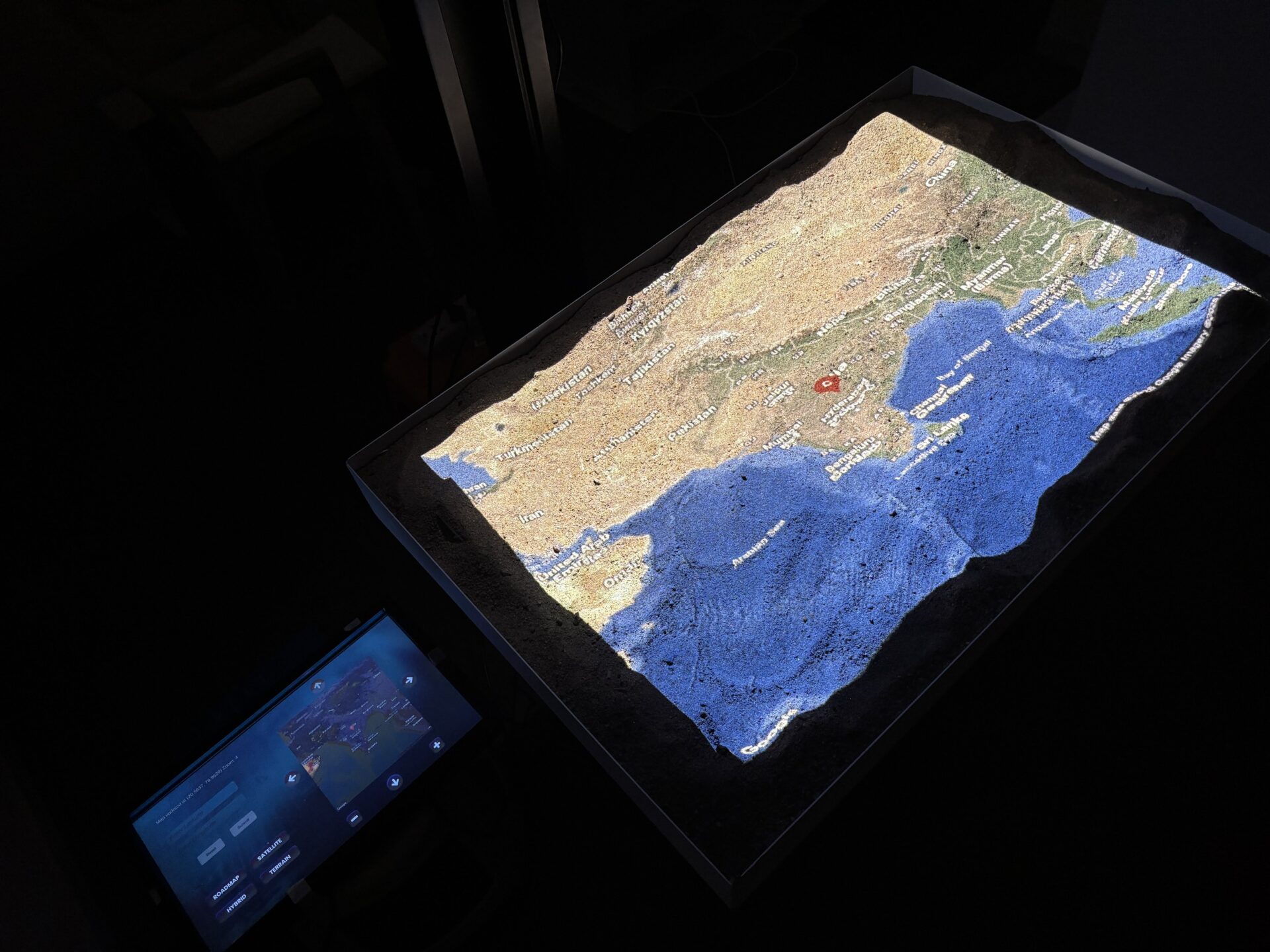


✅ Live Google Maps Integration
Real-time World map rendering via Google Static Maps API with multi-mode support.
✅ Multi-Display Output
Mirror the interactive map on large displays or extended monitors.
✅ Interactive Controls
Touch Based navigation, zoom gestures, on-screen buttons, and marker drops.
✅ Visual Feedback
Dynamic UI with smooth button animations and highlighted states for better user feedback.
✅ Touchscreen Friendly
Compatible with touchscreens and sensor-based inputs (optionally upgradeable).
GENERAL INFORMATION
What is the Interactive Map Sandbox?
Interactive Map Sandbox lets users interact with Online Maps in a sandbox environment for learning, simulation, and design purposes.
Who is this product designed for?
Educators, Army Stations, Naval Offices, students, urban planners, geographers, designers, and anyone interested in interactive map-based learning or presentations.
What features does the sandbox support?
Features include map styling, pin placement, routing, area marking, layering, zoom control, and real-time map interaction.
Is it connected to real-time ONLINE Maps data?
Yes. It uses Online Maps API to fetch live map data.
Can this be used offline?
An internet connection is required for map data retrieval and full functionality.
How can this sandbox help in classrooms?
Teachers can create interactive geography lessons, route simulations, and collaborative map exercises.
Can it be used for remote learning?
Absolutely. It’s optimized for online collaboration and screen sharing.
Is it suitable for kids?
Yes. There’s a kid-friendly version with simplified controls and themes.
Does it align with educational standards?
Yes, we align features with common geography and STEM curriculum standards.
Are there video tutorials available for educators?
Yes. We offer tutorial videos, webinars, and training resources.
Do you offer academic discounts?
Yes, we provide special pricing for schools and universities.
Can I draw paths and shapes on the map?(OPTIONAL)
Yes. The sandbox includes a powerful drawing and measurement tool.
Can I export maps or snapshots?
Yes. You can export maps as images or PDF with annotations.
Does it support multiple map layers?
Yes. You can switch between terrain, satellite, hybrid, and custom layers.
Can I customize the map’s appearance?
Yes, using Google Map styles and our built-in visual editor.
Is location tracking available?
Yes, with permission, it can show your current location.
Can I add custom markers?
Yes. Upload your own icons or choose from our marker library.
What age group can use the Interactive Map Sandbox?
It’s suitable for children aged 5 and up, as well as adults, making it perfect for both education and public engagement.
Can the system be used indoors?
Absolutely. It’s designed primarily for indoor use in controlled lighting environments.
How much space is needed for setup?
A minimum of 6×4 feet of space is recommended for the sandbox and surrounding movement.
Is this a standalone product or does it require a PC?
It typically includes a high-performance PC with pre-installed software, but configurations may vary.
What is the warranty period?
Our standard warranty is 1 year, with extended warranty options available.
Can we add our school logo to the software interface?
Yes, branding and interface customization are available.
Can we request a specific sandbox size?
Yes, sandbox dimensions can be customized to fit your space.
Can we choose the terrain color schemes?
Yes, color schemes can be adjusted within the software settings.
Do you offer white-label or OEM options?
Yes, white-label partnerships are available for resellers or educational companies.
Do you offer on-site installation services?
Yes, we offer on-site installation globally.
What are the power requirements?
A single 220V power outlet is sufficient.
Does it need special lighting conditions?
Dim or moderate indoor lighting is ideal for best projection visibility.
Can we move it from one room to another?
Yes, mobile-frame versions are available with wheels and locks.
Can we use kinetic or play sand?
We recommend Clean, Dust Free, dry play sand without moisture for optimal performance.
Do you ship internationally?
Yes, we ship worldwide with customs support.
Is there documentation or a manual?
Yes, a full user manual and troubleshooting guide is included.
How does this support hands-on STEM learning?
It combines tactile interaction with real-time data visualization, supporting kinesthetic learning.
Can it be used at science fairs?
Yes, it’s a popular attraction at educational exhibitions and fairs.
Can it be used for special education?
Yes, its tactile and visual features make it accessible for diverse learners.
Is it useful for urban planning or architecture?
Advanced versions can support professional terrain modeling applications.
Is it appropriate for museums?
Yes, it enhances visitor engagement in geography and natural history exhibits.
Can it simulate historical terrain changes?
With custom scenarios, yes—it can recreate ancient landscapes.
Can we track learning outcomes?
Optional modules allow for basic learning analytics and assessment.
Can tourists or visitors use it as a local map guide?
Yes, custom maps of local areas can be projected for visitor use.
How does it compare to traditional sandbox tools?
It adds a digital layer to traditional sandbox play, enhancing interactivity and visualization.
Does it support climate or rainfall studies?
Yes, rainfall simulation and terrain runoff are part of the advanced features
Which areas do you ship within India ? We ship to New Delhi, Mumbai, Bengaluru, Chennai, Kolkata, Hyderabad, Pune, Jaipur, Lucknow, Kochi, Ahmedabad, Chandigarh, Srinagar, Amritsar, Bhopal, Indore, Nagpur, Thiruvananthapuram, Coimbatore, Visakhapatnam, Agra, Varanasi, Mysuru, Surat, Vadodara, Patna, Bhubaneswar, Guwahati, Dehradun, Shimla, Mangalore, Rajkot, Jodhpur, Ludhiana, Kanpur, Udaipur, Jamshedpur, Noida, Faridabad, Ranchi, Meerut, Gwalior, Raipur, Jabalpur, Allahabad, Ghaziabad, Gorakhpur, Solapur, Madurai, Vijayawada.
Which areas do you ship outside India & Overseas ? Over overseas delivery covers United States, Canada, Brazil, United Kingdom, France, Germany, Italy, Spain, Russia, China, Japan, South Korea, Australia, New Zealand, Mexico, Argentina, South Africa, Egypt, Turkey, Greece, Sweden, Norway, Finland, Denmark, Ireland, Switzerland, Netherlands, Belgium, Austria, Portugal, Poland, Ukraine, Hungary, Czech Republic, Israel, Saudi Arabia, United Arab Emirates, Singapore, Malaysia, Thailand, Indonesia, Philippines, Vietnam, Chile, Colombia, Peru, Venezuela, Nigeria, Kenya, Morocco.
 Optimized by Seraphinite Accelerator